Wednesday, January 10, 2018, 9:30 AM
Oakland Lake Park, Queens Co. NY
Trip Leader: Andrew Greller
We will walk around the lake to inspect and identify the large, old trees that cover the uplands. This is an area rich in hardwood species, such as oaks, maples, birch, hickories, ash, alder, willow and other species. If time and weather permit, we may later take a walk south along the CIP, to view the giant tuliptrees and beeches that line the trail. Meet at the lake, on 223rd St./Cloverdale Blvd., just S of Northern Blvd., in Bayside. Dress for the weather; waterproof footwear may be useful. Hand lens, camera and binoculars recommended. Bring a liquid and snack or sandwich, as desired.
A joint trip with North Shore Audubon Society
Directions:
Take Cross Island Parkway, and exit at Northern Boulevard, West. The lake is one block west of the CIP, so make the first left, at 223rd Street, and park on the street near the lake.
Saturday, April 7, 2018, 10 AM
Hunting for Marine Algae at Sagamore Hill NHS
Sagamore Hill National Historic Site, Oyster Bay, NY
Trip Leader: Andrew Greller
We will hike down to the shore to identify the marine algae that wash up at high tide. Pick up a guide to Marine Algae of the East Coast of North America, and bring it along to help with identification. There may be spring wildflowers out and we will look for them, as well as for the remnants of higher plants of the coastal sands. Dress for the weather; rubber boots will be useful. Bring a liquid and snacks. Hand lens may be useful. Meet at the parking lot. Extra 9 AM attraction: Sagamore Hill is offering LIBS members an early-bird first floor walk-through of Theodore Roosevelt’s home prior to the algae field trip. Entrance to the home is limited to 15 people, so if you are interested, please RSVP to Lois Lindberg.
Directions:
Take either the Northern State Parkway to Exit 35N or the Long Island Expressway (I-495) to Exit 41N. At those exits, take Route 106 North for approximately 6 miles to downtown Oyster Bay. Turn right onto East Main Street (at Nobman's Hardware Store) and travel 2 miles on East Main Street/Cove Road. Turn left onto Cove Neck Road and drive 1.5 miles to Sagamore Hill National Historic Site.
Saturday, May 5, 2018, 10 AM
A Spring Walk Through Welwyn
Welwyn Preserve, 100 Crescent Beach Rd, Glen Cove, NY
Trip Leaders: Al Lindberg, Lois Lindberg, & Lisa Synoradzki
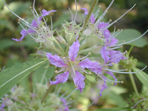
We will explore Welwyn’s diverse habitats, from its tuliptree swamp forest, freshwater streams through the saltmarsh, and down to its sandy beach on Long Island Sound, while searching for an assortment of spring ephemerals and Long Island rarities. Rarities will include striped maple (Acer pennsylvaticum), Ohio buckeye (Aesculus glabra), yellow birch (Betula alleghaniensis) and American bladdernut (Staphylea pinnata). Dress for the weather and please bring a beverage, snacks or lunch, and sunscreen. Welwyn has been noted for its ticks so please also bring insect repellent.
Directions:
From the East: Long Island Expressway to Exit 41 North – NY-106/107 N. Bear left where the two roads split to stay on Route 107N, continue for approx. 7 ½ miles into Glen Cove. Where Rte. 107 ends at the Glen Cove Fire Dept, turn right onto Brewster St. Continue for ½ mile, turn left onto Dosoris Lane. Go ¾ mile, turn left on New Woods Rd. and take it to the end. Turn right onto Crescent Beach Rd, Welwyn Preserve is the first driveway on the right. Continue along the driveway to the main parking lot. From the West: Long Island Expressway to Exit 39 North – Glen Cove Road. After 4 miles, Glen Cove Rd. merges with Route 107N. Continue north on Rte. 107 into Glen Cove and follow the above directions.
Saturday, June 16, 2018, 9 AM
Brookhaven National Laboratory
Forest and Fuels Management Area/Wildfire Area
Trip Leader: Kathy Schwager
Trip is limited to 18 people.
*Registration is REQUIRED by June 14*
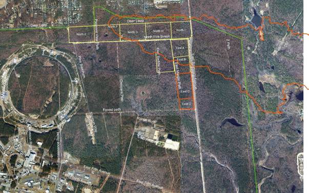 Field Trip Area
Brookhaven Lab is located in the Central Pine Barrens Region of Long Island, which has evolved over thousands of years in the presence of frequent fires. As a result, plant and animal species of the Pine Barrens have adapted to conditions created by periodic fires. A wildfire burned through a portion of the Lab site in 2012. Prescribed fire has been implemented to not only reduce fuels, but to promote forest regeneration by helping remove vegetation and leaf litter that prevent pines, oaks, and other native species from germinating. We will meet first in Building 860 for a brief introductory presentation. We will then proceed to the prescribed burn units and Crescent Bow wildfire area to look at post-fire regeneration and the differences between burned and unburned areas as well as the effects of different kinds of fire to the ecosystem. Please bring sufficient food and water, tick repellent, long pants, and appropriate footwear.
For further information and to register, please contact Kathy Schwager (kschwager@bnl.gov).
Directions:
Directions to the Lab can be found at https://www.bnl.gov/maps/index.php at the bottom of the page. Specific directions to Building 860 from the front gate can be found by clicking on the “Building Locations & Custom Map Points” tab. You will be required to go through security at the front gate so please make sure you have valid identification (driver’s license or such) to present. Anyone who has not pre-registered will be turned away at the gate.
Saturday, July 14, 2018, 10 AM
Shore Road to Wawapek, Cold Spring Harbor, NY
Trip Leaders: Jane Jackson & Amanda Furcall, North Shore Land Alliance
An introduction to two land trust acquisitions:
Shore Road Sanctuary, formerly owned by ExxonMobil, was a fuel oils terminal for decades prior to its remediation and transfer to the Land Alliance. Undergoing a habitat restoration plan, it is now a thriving grassland with pockets of maritime shrubland and wet meadow communities in progress, alongside a shoreline punctuated with tidal marsh species. Wawapek, a former estate once slated for conversion to 13 house lots, contains remnants of a formal garden alongside dense hardwood forest that slopes dramatically down to the Harbor. We will stroll along (and off!) trails through both preserves as we explore the past, present and future of these special parcels. We will begin at 95 Shore Road, then drive up Snake Hill Road from there to Wawapek. Dress for the weather; waterproof footwear may be useful. Camera and binoculars recommended. Bring a liquid and snack or sandwich, as desired.
Directions:
From the LIE to 95 Shore Road, Cold Spring Harbor: Take the LIE to Exit 44 to Route 135 North. At end of 135 North turn right onto Route 25/Jericho Turnpike going east toward Woodbury. Travel approximately .6 mile, then turn left/north onto Southwoods Road. At the end of Southwoods Road bear right onto Cold Spring (or Cold Spring Harbor or Cold Spring Harbor–Syosset!) Road. At the end of Cold Spring Road (there are a light and a stop sign here) turn right onto Route 25A. Travel east approximately 1.7 miles along Route 25A to Shore Road in Cold Spring Harbor (at light near fire station on the right at western end of the Village). Turn left onto Shore Road. Travel approximately 6/10 of a mile north on Shore Road to the preserve. The parking area is very small; you may park on the lawn at either side of it.
Saturday, September 8, 2018, 10 AM Add to Calendar
Hempstead Plains Flora
Hempstead Plains Preserve, Nassau County
Hempstead Plains Education Center, Garden City, NY
Trip Leaders: Steve Young and Greg Edinger
The Hempstead Plains Preserve is the last remaining grassland that was part of a huge expanse of grassland in Nassau and Suffolk Counties. Fourteen rare plants have been documented there and three of them are the largest occurrences in the state. Steve Young, chief botanist of the New York Natural Heritage Program and Greg Edinger, chief ecologist, completed a survey of the plains and the adjacent Purcell Preserve in 2017. Join them for a look at the plants and communities of both preserves and how the area has changed over the years from extensive grasslands to airfields to the remaining green space we see today. The trip will end around 3 pm. There is no limit to the number of attendees but please register by contacting Steve with your name and contact phone number at 518-588-8360 or nyflora1@gmail.com. Steve will send out directions and information as the date approaches.
Joint trip with the New York Flora Association
Saturday, October 20, 2018, 10 AM Add to Calendar
Hallock State Park Preserve, Riverhead Township, Suffolk Co.
Trip Leaders: Eric Lamont and Gil Hanson
Botany and Geology
We will meet at the visitor’s center for an introduction to the land use history of the park and then take a leisurely hike to the dunes and bluffs overlooking Long Island Sound looking at autumn wildflowers and interesting geological features including hoodoos, locally called “The Pinnacles.” The land was acquired in the 1960s for use as a sand mining operation by the Levon Corp. and, in the 1970s, by the Long Island Lighting Co. as the site for a proposed nuclear power plant. New York State purchased the property in 2002 and opened it to the public in 2017.
Please register by contacting Eric (elamont@optonline.net) with your name and contact phone number. Bring a liquid and snack or sandwich, as desired
Directions:
Take the Long Island Expressway (I-495) east to exit 73, continue east on County Road 58 (aka Old Country Road) to Northville Turnpike, continue north to Sound Avenue and turn east for 3.4 miles to the park’s entrance (the visitor’s center is located off Sound Ave.). The address is: 6062 Sound Avenue, Jamesport.